CloudSat - a $217 million satellite designed in Colorado to peer deep into clouds for clues on weather and climate - has given scientists around the world a wealth of information since its April 2006 launch.
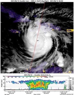
Despite the enormous number of images of clouds from space, previously there had been little real information about the properties of clouds. CloudSat is the first radar to look vertically at the characteristics of clouds, particularly their water and ice content. That data will help scientists better predict weather patterns and climate changes.
Those improvements will give us more confidence in predicting droughts and severe storms in the future, including the effects of global warming.
CloudSat
Since 1993, I have dedicated my career to proposing and implementing the CloudSat mission. Working with NASA's Jet Propulsion Laboratory and my crew at Colorado State University, we saw the immense potential of multi-satellite observations to provide improved data to the scientific community and championed the approach of formation-flying CloudSat with the CALIPSO satellite.
Among some of the new discoveries gathered in the first 12 months of CloudSat's operations:
The CloudSat radar also provides observations of clouds over the polar regions during winter. These clouds have been largely invisible to earlier satellite observations because of the lack of sunlight and the difficulty of sensing a difference, from space, between cold clouds and cold ice-covered surfaces. As we are finding out, the polar regions are extremely sensitive to climate warming, and the complex interplay between the polar surface and polar clouds can now be studied for the first time.
Water is our planet's most precious resource. Through evaporation, water moves from the land surface and ocean to the atmosphere and returns back to the surface in the form of rain and snow. This recirculation of water is known as the water cycle. Not only are clouds one of the most commonly recognized aspects of weather, they are the way that the water cycle transports the fresh water that we depend upon, replenishing the freshwater reservoirs in lakes, rivers, snowpacks and even underground aquifers. Without clouds, our freshwater resources would eventually disappear and all water on this planet would be locked in the saltwater of the oceans.
Clouds also exert a large influence on the climate of our planet, not only by way of the precipitation they produce but also by altering the Earth's greenhouse effect in ways that are not yet fully understood. It is for these reasons that clouds and their effects on climate are one of the most uncertain aspects of the recent Intergovernmental Panel on Climate Change projections of climate change.
Perhaps the most urgent issue of climate change is associated with uncertainties of how rainfall and snowfall may change in a warming climate. Will wet regions get wetter and dry regions get drier? Will storms become more frequent and more severe? Answers to these questions depend upon improving our understanding of how clouds form, how much water they carry, what determines when and how much they precipitate, and how precipitation may be influenced by temperature and pollution.
CloudSat goes a long way toward fulfilling scientists' desire to answer those questions. The data retrieved from the satellite go directly to the Air Force, which then sends all of it to the Cooperative Institute for Research in the Atmosphere, based at CSU. CIRA then processes the data for the scientific community.
Missions such as CloudSat take a decade or more to conceive, propose, and implement. CloudSat owes its success to the scientific leadership of scientists at Colorado State University; a team of engineers and mission designers at NASA's Jet Propulsion Laboratory in Pasadena, Calif.; spacecraft designers at Ball Aerospace and Technologies Corp. in Boulder; satellite controllers at the U.S. Air Force in Albuquerque, N.M.; and a host of international and interagency scientific collaborators.
NASA has recently recognized the enormous early success and promise of the CloudSat mission by extending its funding by three years, to 2011. That decision makes CloudSat the only Earth science mission selected by NASA to receive additional funding for enhanced scientific research beyond the mission's original purpose.
For more on the CloudSat project, go to cloudsat.atmos.colostate.edu, or www.cloudsat.cira.colostate.edu.
Graeme Stephens is a University distinguished professor at CSU and a principal investigator of the CloudSat mission