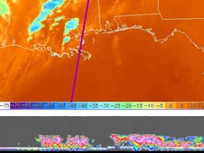
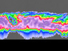
The intense thunderstorms responsible for this week's deadly outbreak of tornadoes in Tennessee, Kentucky, Mississippi, Alabama and Arkansas were imaged by the Cloud Profiling Radar on NASA's CloudSat...
Latest News

CloudSat Profiles Tornadic Outbreak
02.08.08 - The intense thunderstorms responsible for this week's deadly outbreak of tornadoes in Tennessee, Kentucky, Mississippi, Alabama and Arkansas were imaged by the Cloud Profiling Radar on NASA's CloudSat satellite on February 5.
› Full image and caption
Latest Images
CloudSat Profiles Tornadic Outbreak
A 3-D Scene From Dean
Tropical Storm Andrea
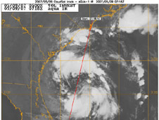
CloudSat's Cloud Profiling Radar captured a profile across Tropical Storm Andrea on Wednesday, 9 May 2007, near the South Carolinal/Georgia/Florida Atlantic coast.
Mission News

NASA Satellites Help Lift Cloud of Uncertainty on Climate Change
New findings from NASA's CloudSat and other spacecraft in NASA's "A-Train" constellation of five Earth observing satellites offer important insights into this year's record reduction of Arctic sea ice, global rainfall patterns and the effects of pollution on clouds.
-

Improving Estimates of a Hurricane's Punch
As Tropical Storm Noel churns off Florida's east coast, NASA and university scientists have announced they have developed a promising new technique for estimating the intensity of tropical cyclones from space.
Video Gallery

CloudSat: Looking Inside Clouds
For the first time, scientists will be able to see clouds in 3-D.
› View This Video
NASA Podcasts
Related Sites
+ View site
Data Processing Center
+ View site
Colorado State University's mission site:
+ View site
CALIPSO mission:
+ View site
Launch Coverage

CALIPSO and CloudSat Launch
Take a look back at pre-launch and launch coverage activities.
› View Launch Archive
› View Launch Video →


